

Mapas que narran historia(s)
Mapas interactivos

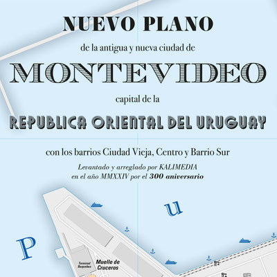
300 años de Montevideo Historia viva, donde el pasado se abraza con el futuro.

América del Sur: proyectos, estadísticas, edificios, lugares y mucho más.

Turismo en Uruguay
Un país, muchas posibilidades

¡Lo ponemos todo en un solo mapa!
Un geoportal turístico para Uruguay

Proyecto "Máquina del tiempo carto-gráfica" con una precisión de 10 metros

Datos estadísticos Ejemplos de las posibi-lidades de la visualización
cartográfica
Viajes en el tiempo, reconstrucciones, desarrollos, trayectorias vitales, estadistíca, turismo y otros mapas temáticos
Nuestro lema:
Todos los acontecimientos de la Tierra tienen una referencia geográfica y, por tanto, pueden representarse en un mapa. Incluso las interdependencias más complejas (con raíces históricas) pueden explicarse fácilmente con storymaps* (mapas narrativos).
Basándonos en sistemas de información geográfica y mapas interactivos, diseñamos y desarrollamos soluciones individuales para la transferencia de
conocimientos, educación, presentaciones, publicaciones, conferencias y análisis para instituciones de investigación y educativas, autoridades públicas, instituciones turísticas y museos, entre
otros.
Nuestra visión
Tenemos la visión, de crear un atlas interactivo como portal geográfico cultural, altamente preciso y expandible para la educación nacional y la transferencia rápida de conocimientos, basado en Storymaps, que visualice y explique de manera clara todos los temas y aspectos geográficos e históricos relevantes de Uruguay.
otros ejemplos interactivos (actualmente sólo en inglés)

Expreso de Oriente
Rey de los trenes - Tren de Reyes

Atlas de los Nombres verdaderos Una serie de mapas etimológicos

¡Aníbal ad portas!
Roma contra Cartago

La ciudad como organismo
Observaciones sobre la autosimilitud

El maldito cementerio
Afuera, devorado, desapareció

Taxi a Kreuzberg
Un viaje por la época del Muro de Berlín
Galería


* Los Storymaps son compilaciones de mapas interactivos multimedia que pueden reproducirse como una película
desplazándose a la velocidad que elijas. Utilizan un diseño web responsivo que se adapta al tamaño del dispositivo final correspondiente. Aumentar el tamaño
de la pantalla optimiza el rendimiento.
Mapas detallados impresos
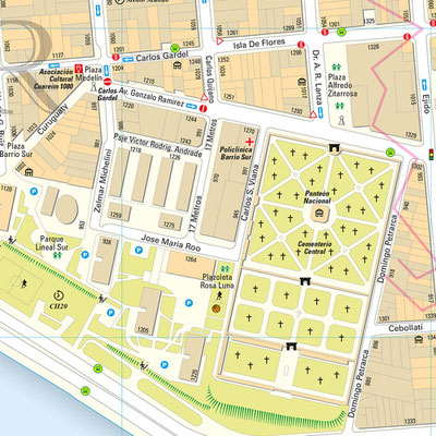
Montevideo grande

con los barrios Ciudad Vieja, Centro y Barrio Sur | formato A0 (118,9 cm x 84,1 cm)
Además de todos los museos, teatros y edificios administrativos etc., el
mapa contiene números de acceso, señales de tráfico, calles de sentido único, semáforos, las defensas históricas, el barrio de El Bajo, lugares del pasado y mucho más.


Uruguay


Mapas precisos y detallados de las ciudades europeas


Temas extraordinarios


Trabajos por encargo (selección)


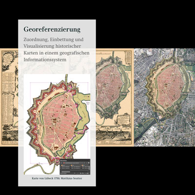
Restauración digital y georeferenciación de mapas históricos


Independientemente del alcance del proyecto, hemos desarrollado conceptos para una
implantación rápida y rentable. Póngase en contacto con nosotros.
Calendario y costes
realización rápida y rentable
Concepto 10 semanas
plazo de tramitación 10 semanas
Concepto de 4 dígitos
1000 US$ a máx. 9999 US$ + IVA
Perfil
Periodismo cartográfico
• Investigación
• Editorial
• Palabra
• Imagen
Sistemas de información geográfica
• Gestión de geodatos
• Georeferenciación
• Attribución
• Dimensión de los datos: 0D - 4D
Cartografía web
• ESRI - ArcGIS Online, Story Maps
• Illustrator • MaPublisher
• Photoshop • Geographic Imager
• QGis
Calidad de los datos
• Exhaustividad
• Precisión posicional
• Precisión temporal
• Precisión temática
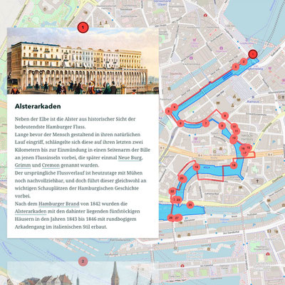
Storymaps
• Viajes en el tiempo, incidentes
• Recontrucciones, evoluciones
• Trayectorias vitales, recorridos
• Perspectivas, lugares de la memoria
ESRI frente al software libre
• posibilidades incomparables
• sin esfuerzo de programación
• servicio y asesoramiento completos
• análisis coste-beneficio positivo
Reseñas de prensa (selección)
In Place Names, Old Meanings Made New
New York Times
BBC World Radio
VIDEO: BBC News Television
Bizarre new atlas comes to the Great Land of the Tattooed
Daily Telegraph
The astonishing map that reveals the origins of place names
Daily Mail
Daily Mail
Ontario placenames: An etymological approach
Toronto Star
The U.S. With Literal Translations OF State Names
Huffington Post
Amazing 'Atlas of True Names' Is Our New Favourite Thing
Huffington Post
Re-Writing Mapped Space: Maps as Texts
Dan Brownstein
An Etymologist's View of the World
Spiegel Online International
Slate.com
MLive.com
Strange Maps
VIDEO: RTVE Televisión (España)
Así es el mapa mundi de los nombres verdaderos
ABC (España)


STORYMAPS.DE ist eine Internetseite von / is a website from / es un sitio web de:
KALIMEDIA • map design & map journalism • Diseño y periodismo de mapas
Stephan Hormes & Silke Peust • Calle Cerrito 663 bis · 11100
Montevideo/Uruguay
Mail: info@storymaps.de · Tel: ++49 177 728 27 16 (WhatsApp) · ++598 98 298 731
